International and interstate waterways in the Republic of Serbia
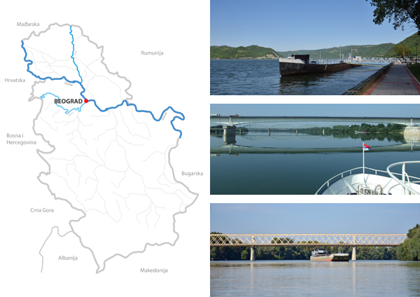
Danube
The Danube (German-Donau, Slovakian-Dunaj, Hungarian-Duna, Ukraine-Dunay, Romanian-Dunărea, Turkish-Tuna) is the longest river in the European Union and the second longest river in Europe after the Volga River. The river originates in the Schwarzwald mountain range from smaller rivers Brigach and Breg, near town of Donaueschingen. Length of the Danube River is 2850 km and flows through several Central European capitals, before emptying into the Black Sea via Danube Delta in Romania and Ukraine.Rhine-Danube Corridor is one of the nine European corridors of TEN-T network, which passes through the Republic of Serbia with the length of 588 km – from Bezdan to Timok. Out of that, 137.6 kilometres represent joint sector with Republic of Croatia and 299.35 kilometres joint sector with Romania.
Regulation of the Government of Republic of Serbia on determination of international and interstate waterways (“RS Official Gazette” No. 109/16) defines the Danube River as international waterway on the entire length of the flow through Republic of Serbia, from km 845+500 to km 1433+100.
With Regulation of the Government of Republic of Serbia on categorization of international and interstate waterways (“RS Official Gazette” No. 109/16), waterway of the Danube River on the stretch from km 845+500 to km 1170 has the category VII and on the stretch from km 1170 to km 1433+100 has the category VIc.

Sava
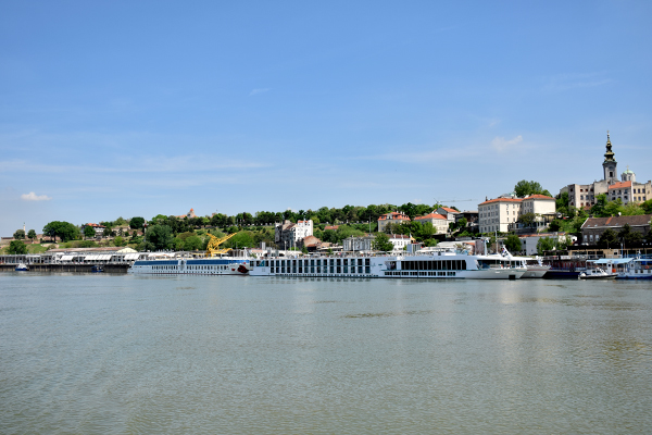
The Sava River is the third by length and the largest by flow tributary of the Danube. Length of the Sava River from its confluence in the mountains of West Slovenia to the confluence with the Danube in Belgrade is 944 km. The Sava flows through four countries (Republic of Slovenia, Republic of Croatia, Bosnia and Herzegovina and Republic of Serbia) connecting three capitals from these countries: Ljubljana in Republic of Slovenia, Zagreb in Republic of Croatia and Belgrade in Republic of Serbia. The surface of basin is 97,713 km² which covers a significant part of Republic of Slovenia, Republic of Croatia, Bosnia and Herzegovina, Republic of Serbia, Montenegro and a small part of Republic of Albania.The Sava River represents an international waterway. The Framework Agreement on the Sava River Basin was signed in 2004 by Republic of Slovenia, Republic of Croatia, Bosnia and Herzegovina and Republic of Serbia, and the International Sava River Basin Commission (ISRBC) started with work in 2006.
Regulation of the Government of Republic of Serbia on determination of international and interstate waterways (“RS Official Gazette” No. 109/16) defines the Sava River as international waterway on the entire length of the flow through Republic of Serbia, from km 0 to km 210+800.
With Regulation of the Government of Republic of Serbia on categorization of international and interstate waterways (“RS Official Gazette” No. 109/16), waterway of the Sava River on the stretch from km 0 to km 81 has the category Va, on the stretch from km 81 to km 176 has the category IV, on the stretch from km 176 to km 196 has the category III and on the stretch from km 196 to km 210+800 has the category IV.
Tisza
The Tisza River (Hungarian: Tisza, Ukraine: Tisa, Slovakian and Romanian: Tisa and German: Theiß) is the largest left tributary of the Danube. It flows through the Pannonian Plain. Its confluence is in Ukraine, in the Carpathian Mountains in Bukovina region and passes through Hungary, Romania, Slovak Republic and Republic of Serbia. The Tisza River is emptying into the Danube opposite to Old Slankamen (Stari Slankamen).The Tisza River is 1,358 km long. In the region of Vojvodina, the Tisza River divides Bačka (right bank) and Banat (left bank). The longest tributary of the Tisza is Mureš, followed by Begej, Bodrog, Zlatica, Kereš, Samoš and Šajo. The Tisza River is navigable with length of 532 km and flows through Serbia with length of 164 km.
Regulation of the Government of Republic of Serbia on determination of international and interstate waterways (“RS Official Gazette” No. 109/16) defines the Tisza River as international waterway where international regime of navigation applies on the entire length of the flow through Republic of Serbia, from km 0 to km 164. Therefore, navigation on the Tisza River is free and open to vessels from all states regardless to the flag of vessels.
With Regulation of the Government of Republic of Serbia on categorization of international and interstate waterways (“RS Official Gazette” No. 109/16), waterway of the Tisza River on the stretch from km 0 to km 164 has the category IV.


- 19.06.2023.General repairs of the Serbian lock Iron gate 2In the period from July 18, 2023 to July 17, 2024, the Serbian lock Iron Gate 2 will be out of use because of general repairs....
full story - 30.12.2020.New Electronic Navigational Charts for the Danube RiverPlovput published new Electronic Navigational Charts for the Danube River in Inland ECDIS standard 2.3....
full story - 30.12.2020.Plovput published Navigational Chart of the Sava RiverThe sixth edition of the Navigational Chart of the Sava River available at the internet presentation of Plovput...
full story - 30.12.2020.Plovput published the new edition of the Danube River Navigational ChartThe eight edition of the Navigational Chart of the Danube River available at the internet presentation of Plovput...
full story


